Even though this current January was dry, at least we can read about local winters awash in rain a century and a half or two ago. The January 15th, 1965, Lafayette Sun took a look back at the rainfall records left from the California Mission era.
“That rainstorms in 1805 created statewide havoc was verified by the records of Southern mission padres. Proof of the record-breaking 1861-62 deluge was corroborated later when water marks were found in trees in the San Joaquin Valley, showing that a former flood had been fully six feet higher.
“The padres recorded a rainfall in 1819 so great that rivers changed their beds. Historians mentioned the winter of 1825-26, 1840 and 1846-47, when great numbers of stock were lost by drowning.”
From the same sources we learn of extremely dry years. In fact, the Native Americans told of a year in which no rain fell at all—the drought of 1824, which caused cattle to die by the thousands. And the year 1831 was so dry [here I heard the voice of Johnny Carson’s audience calling out: “How dry was it?”……but I digress], Historian William Heath Davis wrote, that rancheros killed thousands of horses to preserve what little feed there was for their cattle.
Official weather records were kept beginning in 1849. From that year to 1914, Contra Costa County experienced 11 floods, and there were 21 drought years.
A 1970 history of the Municipal Utility District (entitled Its name was M.U.D), reported that the winter of 1850-51 had been unusually dry, a mere 7.1 inches of rainfall, and by summer the springs and creeks carried far less water than before. “Few at the time might have guessed, but the problem of water was to become the most vexatious and turbulent the area was to have over the next 60 years. It only grew more complex as communities expanded and natural water sources disappeared.” And 1860 was a short rain year, as well, and what water there was quickly ran off the denuded slopes, where trees had been clear-cut to provide lumber for the fast-growing Bay Area.
But according to William Brewster, in his journal Up and Down California in 1860-1864, “Between November 1861 and January 31, 1862, 102 inches of rain fell in the Central Valley, which was one vast lake 250–300 miles long and 20–60 miles wide. The winds made high waves of the cold, muddy waters that beat to pieces farm dwellings that had withstood the flood waters.
“The course of the river itself could be told only by treetops. River steamers were used to get to ranches 14 miles from the river. Isolation from the east, where the Civil War raged, was complete. Bridges and roads were destroyed, so that the Overland could not operate. [Beginning in 1857, the Overland Mail Company carried mail from St. Louis to San Francisco twice a week.] Even the telegraph was not working, for in the Sacramento Valley, for some distance, the tops of the poles were under water. An eye-witness account of the view from Mt. Diablo was that the San Francisco Bay appeared small compared to the muddy sea to the east.
“Warehouses along the waterfront and their contents of wheat were swept away. Recurring floods brought more mud and silt from upstream that filled the slough and overflowed into the town.”
And one additional peril: “In 1862 the Bay Area was issued a rattlesnake warning, as the rattlers were washed down from the mountains on floating debris,” Brewster reported.
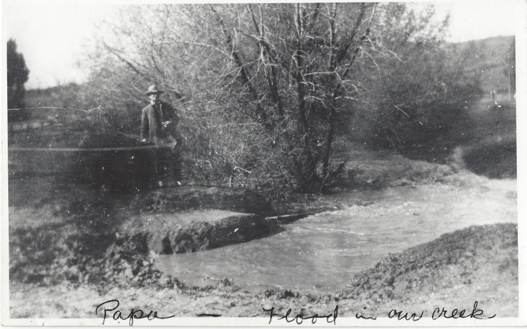
As the song goes, we’ve seen fire and we’ve seen rain….along with sunny days we thought would never end. Two photos from the LHS archives demonstrate the yin and yang of local rainfall. The circa 1910 flood scene shows Henry Toler Brown (“Papa,” according to writing on the photo margin) near the flooded Lafayette Creek at Oakland Ave. and Mt. Diablo. The other picture is of Dick Francis water witching during the drought of 1977. Any bets on how 2015 will turn out?
-Ruth Bailey


Very interesting and what I try to tell others,we live in a desert that often floods!